
Applied
Atmospheric Dynamics
Amanda H. Lynch
and John J. Cassano

|
|
|
Applied
Atmospheric Dynamics |
|
|
|
|
|
|
|
|
| Wiley Home | Higher Education Home | Title Home | ||
|
|
|
|
|
|
|
Images Storm of 2003 Projects |
Projects: Tornado!The tornado outbreak of May
2003 was a record setting one in the United States. From May 3-11, 361
tornadoes were reported in 26 states with 41 reported fatalities, 642
injuries, and over $800 million in property damage. In Missouri on May
4, several tornadoes struck, hitting the towns of Stockton and Pierce
City particularly hard, with 19 reported fatalities and massive damage
to their downtown business districts. The Oklahoma City area was also
hard hit, including an F4 tornado which struck on May 8 in the southern
Oklahoma City metropolitan area. The city of Moore, Oklahoma reported
300 homes destroyed and 1500 damaged. The next day, a single supercell
thunderstorm produced ten tornadoes in central Oklahoma, including an
F3 which struck in the northern Oklahoma City metropolitan area. Tornadoes can also be associated with landfalling hurricanes. In September 2004, Hurricane Ivan spawned 117 tornadoes over a 3 day period in the United States, causing 8 deaths and 17 injuries. On September 15, an F2 tornado struck near Panama City Beach, FL which caused 1 death and 7 injuries. Also on that date, another F2 tornado struck near Bountstown, FL, resulting in 4 deaths and 1 injury. Project ObjectiveThe project objective is to learn to work with weather data and eyewitness reports in order to construct a detailed picture of a tornado outbreak. This weather data will also be used to understand the environment which is conducive to tornado development and to compare and contrast the environments of supercell tornadoes and tornadoes associated with land falling hurricanes.DefinitionsTornado: A violently rotating column of air in contact with the ground, and often, but not always, visible as a funnel cloud.Supercell thunderstorm: A single cell thunderstorm, with the distinguishing characteristic that the updraft of the storm is rotating, forming a mesocyclone. These are the most intense thunderstorms on earth and are responsible for most tornadoes, large hail, and damaging straight-line winds. Fujita
scale: A six-point scale which relates structural and/or vegetative
damage to tornado intensity. Lifted Condensation
Level (LCL): The level in the atmosphere that a rising parcel
lifted dry adiabatically becomes saturated. Equilibrium Level (EL): The level in the atmosphere at which the temperature of a buoyantly rising air parcel is equal to the environmental temperature. Lifted Index (LI):
L = (T500 - TP500)
where T500 is the temperature of the
environmental sounding at 500 hPa and Tp500
is the temperature of an air parcel which was lifted dry adiabatically
to the LCL, then moist-adiabatically to 500 hPa. Typically the
index is calculated based on the sounding taken later in the
day rather than the early morning sounding in order to take
into account afternoon heating. Positive LI numbers mean no
significant thunderstorm or severe potential. Negative LI numbers
are associated with thunderstorm potential, with LI numbers
less than -4 mean severe thunderstorms are probable and tornadoes
are possible.
Individual ActivityPerform a search for information about the Tornado outbreak of 2003 and Hurricane Ivan (some suggested places to look are below in the data and bibliography sections). Where did the storms/tornadoes occur? What were the damage reports? How did the Tornado outbreak of 2003 compare with other tornado outbreaks (e.g. the super outbreak of April 3-4, 1974 which struck 13 states in the Midwest and eastern US, or the tornado outbreak in the central US in May, 1999)? Describe the Fujita scale, including the origin of its development.What are the atmospheric conditions necessary for tornado development? Draw a typical sounding on a skew-t diagram from a day favorable for tornado development. Have you ever seen a tornado? If not, have you ever seen a strong thunderstorm? A hail producing thunderstorm? Describe what you experienced, including the environment before, during, and after the event. Have you ever experienced a hurricane? Did it produce tornadoes? Again, describe what you experienced.
Some suggested investigationsCompare and contrast the supercell based tornadoes from the Tornado outbreak in 2003 and those from hurricane Ivan. What was different about the environment in which they both formed? What was similar?Compare and contrast soundings from tornadoes associated with supercell thunderstorms and tornadoes associated with hurricanes. Were there any differences between the soundings? How were they different, similar to a typical tornado sounding? What are some of the characteristics of the atmosphere on those days that were conducive to tornado development? Describe the
structure and life cycle of a supercell thunderstorm. On
May 9th, 2003, a supercell thunderstorm produced 10 tornadoes
in central Oklahoma. Describe the surface observations before,
during, and after the event. Were the observations what
you expected? Why or why not? DataUse the links below to view data and images from this storm. All images below courtesy of the Storm Prediction Center. Surface observations plots
Upper air Plots
Soundings
Radar
Surface text data May 7-10, 2003, Oklahoma City, OK (OKC) September 14-17, 2004, Tallahassee, FL (TLH) Upper air text data May 7-10, 2003, Norman, OK (OUN) September 14-17, 2004, Tallahassee, FL (TLH) In addition to the data provided above, you may also find other weather data and information on the internet. Some suggested places to try*:
BibliographySome suggested references...
|
Toolbox
|
||||||||||||||||||||||||||||||||
|
|
|
|
|
|
|
Legal Disclaimer | Privacy Policy | ©2006 John Wiley & Sons, Inc. All Rights Reserved |
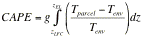 where ZEL is the height of the equilibrium
level and Z LFC is the height of the
level of free convection. CAPE is the maximum energy available
to a rising parcel of air. This is the positive area on a thermodynamic
diagram (where the parcel is warmer than the environment) between
the level of free convection and the equilibrium level.
where ZEL is the height of the equilibrium
level and Z LFC is the height of the
level of free convection. CAPE is the maximum energy available
to a rising parcel of air. This is the positive area on a thermodynamic
diagram (where the parcel is warmer than the environment) between
the level of free convection and the equilibrium level.